ProductsProduct Navigation
 Hot Products
 Solution
 Contact information
Home > Products > Industry products > Forest fire warning command system > Industry Products - Forest Fire Command System Software
Achieving Unmanned Operation and Efficient Management:
Traditional video surveillance relies on 24-hour shifts of personnel monitoring and interpreting video images from various monitoring points day and night. To effectively address issues such as personnel fatigue from prolonged monitoring, personnel management, and work efficiency problems associated with traditional video surveillance, it is necessary to combine traditional video surveillance with automatic smoke and fire detection, identification, and alarm software to achieve unmanned operation and efficient management.
Combining "Eyes" and "Brain":
Traditional video surveillance transmits video images from various monitoring points in the forest area to the control center. The automatic smoke and fire detection, identification, and alarm software then automatically identifies fire points and issues alarms—this only fulfills the function of the "eyes." How can we analyze and determine the location of fire points and the trend of fire spread in real time? How can we dynamically analyze the damage caused by the fire? How can we effectively coordinate and organize forest fire prevention personnel and facilities, and implement firefighting command plans? In other words, if the aforementioned "eye" function is not combined with the "brain" function described later, it will be difficult to effectively utilize the real-time monitoring capabilities of the "eyes," and it will be difficult to fully utilize the various resources involved in forest fire prevention monitoring and command management, further improve the overall level of forest fire prevention command and management, and achieve timely and effective fire suppression monitoring and command management results.
Combining "peacetime" and "wartime" management:
Fire prevention monitoring and early warning management is a proactive management function that occurs outside of fire emergency command and management periods, manifested in peacetime or daily operations. Achieving early detection, early resolution, and effective prevention and control is another important aspect of strengthening fire prevention monitoring and management. If "peacetime" fire prevention monitoring and early warning management can be effectively combined with "wartime" fire emergency command and management, the overall level of fire prevention monitoring and management will be significantly improved.
Combining "two-dimensional" and "three-dimensional" management:
The Forest Fire Prevention Monitoring and Command Management System is an information management and command platform supported by comprehensive forest fire prevention geographic information management, centered on a forest fire prevention command and decision support system, and guaranteed by an intelligent integrated dispatching machine. It fully integrates satellite communication, 3G (4G) networks, meteorological information collection terminals, and various communication devices such as individual soldier terminals, walkie-talkies, mobile phones, and landlines. The entire platform mainly consists of an intelligent integrated dispatching machine, a comprehensive forest fire prevention geographic information subsystem, a fire emergency command platform, and a fire emergency command platform client (mobile terminal). The entire platform needs to integrate with the existing "Fire Risk Early Warning and Monitoring System," "Digital Communication System," "Information Management System," "Information Command System," and "Monitoring Area Video Surveillance System."
The system supports high-resolution satellite imagery data and provides unified management of various data sources, including forest fire prevention data, material reserves, forest fire command centers, firefighting forces, water sources, roads, administrative boundaries, attribute data, metadata, forest resource data, and digital elevation models. It can construct a knowledge base related to forest fire prevention research, a fire suppression analysis model library, and a methodology library for loss assessment and performance evaluation. The system provides comprehensive, multi-level decision support and knowledge services for decision-making. It is required to offer scientific forest fire spread simulation, rich information retrieval, accurate decision deployment, professional forest fire mapping, flexible tactical calculations, and an advanced system evaluation system.

Software Functions:
1. Video Surveillance
Real-time access to video from all front-end fire monitoring points, with zoom, focus, pan/tilt/zoom adjustment, and cruise path setting.
2. Fire Identification
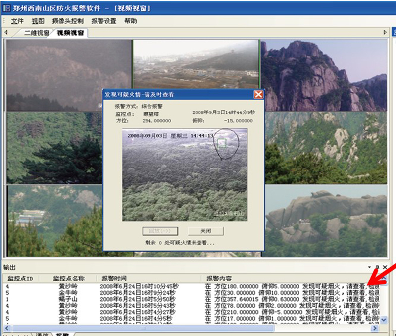
Supports visible light smoke and fire identification and thermal imaging temperature difference warning. Alarm information screenshot processing is also included.
3. Video Storage
Stores video from all front-end monitoring points for 3 months (storage time can be increased according to user needs). Videos exceeding the storage time are automatically overwritten by the oldest.
4. Streaming Media Forwarding
Video collected from the front end is forwarded to various sub-monitoring centers via streaming media, reducing resource consumption.
5. Access Control
Access control between monitoring centers at all levels.
6. Fire Spot Location
Locates hotspots based on angle information transmitted from fire monitoring cameras, including alarm time and latitude/longitude coordinates.
7. Spread Simulation
The software acquires real-time meteorological station monitoring data and combines it with digital elevation models and small-scale data to calculate the fire's development trend over a certain period, simulating it on the platform.
8. Situation Mapping
After a fire occurs, it allows for reasonable planning of firefighting measures and the creation of firefighting plans.
(For more information on features, please contact Shenzhen Huaruitong Technology Co., Ltd.)
Related Products
Understand more>